District Profile & Facts
.1.1 Historical Background
Nakapiripirit District was one of the eleven Districts that were pronounced Districts by the Sixth Parliament of Uganda. It was curved out of Moroto District in 2002. Unlike others, Nakapiripirit has been a District before (1973-1981). Nakapiripirit prior to its status was a District in 1973 and it was then called South Karamoja District with its headquarters at Nabilatuk. But unfortunately, in 1981, Obote II government regime phased out the district and aligned it to Moroto District inform of Pian, Pokot and Chekwii Counties.
Nevertheless, the restoration of Nakapiripirit in July 2001 as a District marked its rebirth to enhance government policies of decentralisation. Consequently, after the curvature of Amudat and Nabilatuk districts from Nakapiripirit district in 2010 and 2017 respectively has left the LG with new administrative units as will be shown later under administrative structure.
2.1 Geographical Location, Land Area and Population
2.1.1 Location
Nakapiripirit is located in Northeastern Uganda with coordinates of 1.8503° N, 34.7216° E. It is around 516 kilometers from Kampala using Kampala-Mbale-Soroti-Moroto-Nakapiripirit road (All Tarmac) and 353 Kilometers from Kampala using Kampala-Mbale-Nakapiripirit through Pian-Upe Game reserves. It is located in the Southern part of Karamoja region bordered in the North by Nabilatuk District, South by Kween, Bulambuli and Bukedia Districts, Katakwi and Kumi Districts in the West and Amudat in the East.
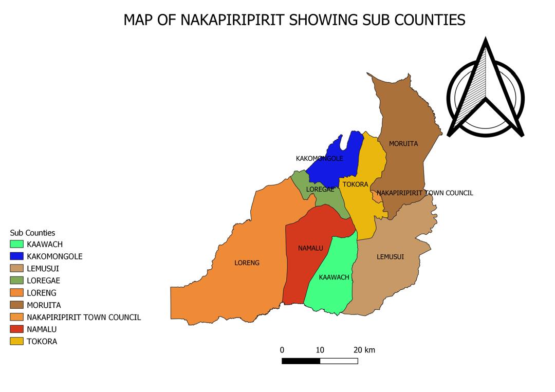
Figure 2. 1: Map of Nakapiripirit and Uganda, showing location of the district
MAP OF UGANDA SHOWING NAKAPIRIPIRIT DISTRICT | MAP OF NAKAPIRIPIRIT SHOWING ADMINISTRATIVE UNITS |
|
|
2.1.2 Land area
The district land area of Nakapiripirit District is about 2,640.7 Km2 comprising of 8 sub counties and 1 Town Council
2.1.3 Population size, density and issues
Nakapiripirit has a total population of 111,681 people with 54,983 males and 56,698 females according to the Population and housing census of 2024.
Figure 2. 2: Map of Nakapiripirit District showing population distribution by Sub County
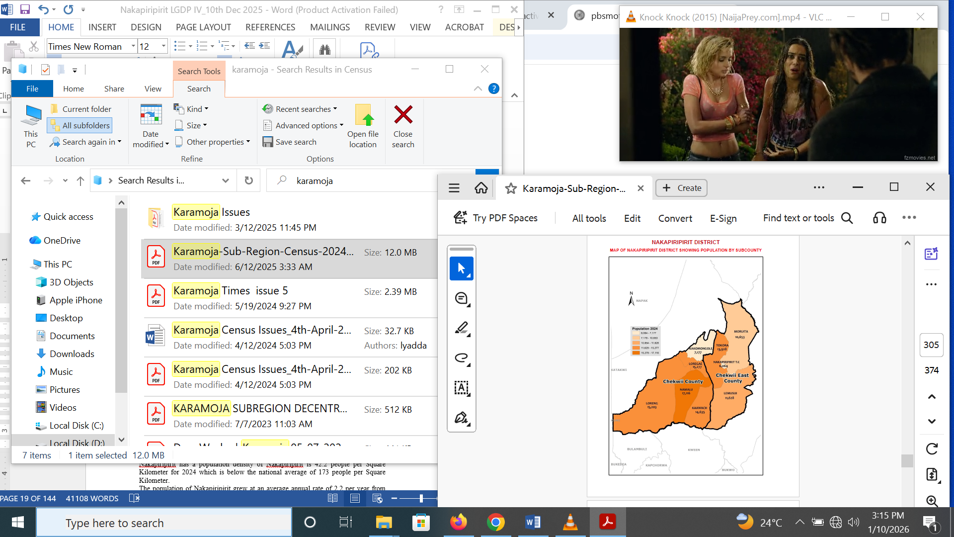
Source: Uganda Bureau of Statistics, 2025
Table 2. 1: Table showing Population figures of Nakapiripirit District by Sub county
Sub Counties | Households | HH size | Sex Ratio | Population | Land Area KM2 | Population Density | ||
Male | Female | Total | ||||||
Kaawach | 3,330 | 4.4 | 87.5 | 6,829 | 7,806 | 14,635 | 213.3 | 68.6 |
Kakomongole | 1,562 | 4.4 | 96.2 | 3,519 | 3,658 | 7,177 | 135.5 | 53.0 |
Lemusui | 2,443 | 4.4 | 110.6 | 6,106 | 5,522 | 11,628 | 458.1 | 25.4 |
Loregae | 4,558 | 3.3 | 90.9 | 7,274 | 8,003 | 15,277 | 84.0 | 181.9 |
Loreng | 4,127 | 3.6 | 86.1 | 7,032 | 8,171 | 15,203 | 776.8 | 19.6 |
Moruita | 2,351 | 3.9 | 130.5 | 6,031 | 4,622 | 10,653 | 464.3 | 22.9 |
Nakapiripirit TC | 1,110 | 5.4 | 98.6 | 3,011 | 3,053 | 6,064 | 6.8 | 891.8 |
Namalu | 4,158 | 4.1 | 93.8 | 8,283 | 8,833 | 17,116 | 283.6 | 60.4 |
Tokora | 3,345 | 4.0 | 98.1 | 6,898 | 7,030 | 13,928 | 218.4 | 63.8 |
District | 26,984 | 4.0 | 97 | 54,983 | 56,698 | 111,681 | 2,640.7 | 42.2 |
Karamoja | 313,987 | 4.7 | 93.1 | 721,434 | 774,683 | 1,496,117 | 27,528 | 54.3 |
Uganda | 10,698,913 | 4.2 | 94.6 | 22,314,289 | 23,591,128 | 45,905,417 | 241,607 | 190 |
Source: Uganda Bureau of Statistics, 2025
Nakapiripirit has a population density of Nakapiripirit is 42.2 people per Square Kilometer for 2024 which is below the national average of 173 people per Square Kilometer.
The population of Nakapiripirit grew at an average annual rate of 2.2 per year from 91,400 in 2014 to 111,681 in 2024. The high population growth rate has been due to the high fertility estimated at 7.3 children per woman and the reducing mortality with moderate peace prevailing and improvement in service provision particularly health.
Sex ratio
The sex ratio of Nakapiripirit District stood at 97 of which 54,983 are Males and 56,698 are females as shown in Table 2.1 above.
Population structure
According to the pyramid below generated from the 2024 census data, it is noticed the population structure of Nakapiripirit like that of Uganda has a wide base. This shows that Nakapiripirit has a relatively young population with majority of the people 24 years and below composing of 66.7% of the total population form the pyramid.
Figure 2. 1: Population structure of Nakapiripirit
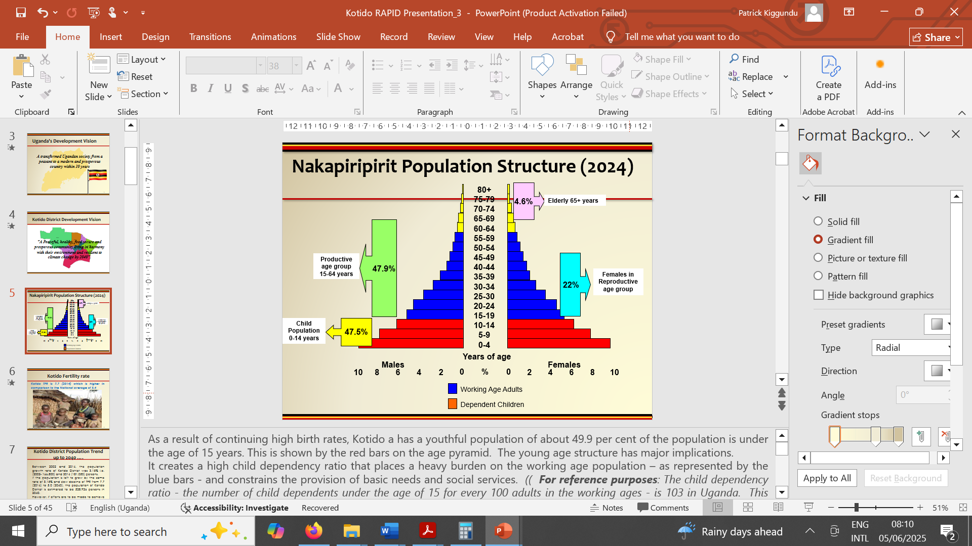
Source: Nakapiripirit RAPID Report
In addition, the census data showed that Nakapiripirit has a predominantly young population with 56.3% aged 0 – 17 years, 22.1% aged 18 – 30 years meaning 77.4% of the population is below 30 years. Only 4.6% of the population was aged 60 years and above.
Table 2. 2: Population by selected age groups for Nakapiripirit in comparison with Karamoja and Uganda
Admin | Children | Adults | Youth | Working age | Older persons | |
(0-17 years) | 18 years and above) | (15-24 years) | (18-30 years) | (14-64 years) | (60 or more years) | |
Uganda | 22,750,701 | 23,154,716 | 9,751,311 | 10,769,151 | 26,156,231 | 2,290,144 |
Karamoja | 837,055 | 659,062 | 283,045 | 359,623 | 741,539 | 60,170 |
Nakapiripirit | 62,823 | 48,858 | 18,822 | 24,702 | 53,467 | 5,140 |
Percentage | 56.3% | 43.7% | 16.9% | 22.1% | 47.9% | 4.6% |
Source: Uganda Bureau of Statistics, 2025
Population density
The population of Nakapiripirit like all other Karamoja Districts is unevenly distributed population which is concentrated in urban centres and many rural growth centres. The Population density of Nakapiripirit is 42.2 people per Square Kilometer for 2024 as shown in Table 2.1 which is below the national average of 173 people per Square Kilometer.
Dependency ratio
Nakapiripirit District has a relatively high age dependence burden or ratio of 113.7% as illustrated in Figure 2.3. The 47.9% of the population (aged 14 – 64 years) are the ones supporting 47.9% (aged 0 – 14 years (49.9%) and 60 and above (4.6%)). This is worsened by the high levels of youth unemployment which impacts greatly on the few people who engaged in gainful employment.
Households
During the census of 2024, Nakapiripirit District had a total of 26,984 households with an average household size of 4.0 and household population of 107,862. Majority of the households in Nakapiripirit are headed by males (79.6%) compared to their female counterparts (20.4).
Table 2. 3: Nakapiripirit Household headship by age
Administration unit | Household head by age | |||
Adolescents 10-19 year | Youths 15-24 year | Youths 18-30 year | Older persons 60+ years | |
Uganda | 3.3% | 12.3% | 29.1% | 15.3% |
Karamoja | 2.5% | 14.5% | 36.7% | 14.2% |
Nakapiripirit | No data | 16.5% | 37.2% | 14.8% |
Source: Uganda Bureau of Statistics, 2025
Table 2.3 above shows that Nakapiripirit had more households headed by youth aged 15-24 years (16.5%), 18-30 years (37.2%) and Older persons 60 and above years (14.8%) compared to the households headed by the same age categories at Karamoja region and National level. This implies most households in Karamoja are susceptible to shocks.
Population issues
Fertility: Fertility is one of the three components of population dynamics. Nakapiripirit registered a high Total Fertility Rate (TFR) during the last conducted census in 2014 which stood at 7.3 children per women. This is high when compared to the national TFR of 4.5 children per woman and Karamoja TFR of 4.8 children per woman established in census 2024. The high fertility in Nakapiripirit is as a result of many factors which include early / teenage pregnancies at 30% compared to national average of 24%, pro-natalist cultural beliefs, and low contraceptive utilization at 7.8% compared to the Contraceptive Prevalence Rate of 35%, among others. This has posed a big challenge to the Nakapiripirit District Local Government in this post-disarmament period as a lot of youths are idle yet more children are coming into the world unplanned for.
Mortality: Nakapiripirit district lies in Karamoja region which has been having poor mortality indicators. According to the 2022 Uganda Demographic and Health Survey, Infant Mortality Rate for Karamoja was better at 26.1/1,000 compared to 36/1,000 at national level. However, Under 5 Mortality was worse with 55.7/1,000 at Karamoja region compared to 52/1,000 and Maternal Mortality was 588/100,000 compared to 189/100,000 at national level. This mainly affects the labour force available for work and has contributed to increased orphanhood in the region
Migration: Nakapiripirit was faced with limited and temporal migration which is mainly internal that is between Villages, Parishes and Sub Counties. The Population of Nakapiripirit characterized by seasonal movements of the people. This is mainly caused by;
• Search for fertile land (Re-settlement)
• Nomadic pastoralism
• Drought and Famine
• Insecurity
• Unemployment
• Breakdown in the social structure
This was supplemented by institutionally organized movements which involve people being directed to greener belts among others for improvement in agricultural production and productivity. Migration in return has caused; increased children on the street, Prostitution, Increased crime rate, increased pressure on social services in receiving areas, Land Depletion, Deforestation, among others.
Literacy
Literacy is the ability to read with understanding and write meaningfully in any language. Literacy in Nakapiripirit was 26.9% as established during the census of 2024 was low and still low compared to 30.4% and 76% literacy rates at Karamoja region level and national level respectively (NPA, 2024; KRDP).
2.1.4 Livelihoods
The livelihoods of people in Nakapiripirit are shaped by the region's semi-arid climate, cultural heritage, underdeveloped infrastructure, and historical reliance on traditional systems of pastoralism.
Livelihood patterns: The population of Nakapiripirit is largely agro-pastoralist with majority of households keeping livestock and some subsistence crop agriculture. Namalu and Kakomongole are the leading sub counties in crop agriculture while Moruita and Loregae are predominantly pastoralist. Households rear cattle, goats, and sheep, which serve both economic and cultural purposes. However, due to recurring droughts, diminishing grazing lands, and climate variability, communities are increasingly supplementing livestock-based livelihoods with subsistence agriculture. The major crops grown include; Sorghum, Millet, Maize, Beans and Groundnuts. The census of 2024 revealed that 70.9% of people in Karamoja were in the subsistence economy which is higher than the national level of 33.1%
Farming is predominantly rain-fed, with limited access to modern agricultural inputs, irrigation, or mechanization. This contributes to low productivity and seasonal food shortages resulting in livelihood instability. People have identified coping mechanisms to improve on their survival which include; charcoal burning, firewood collection, petty trade and informal businesses, and movement to urban areas to provide unskilled labour.
There are so many challenges affecting the livelihoods include; Climate change and frequent droughts, Cattle theft and insecurity, Limited access to markets and services, Poor infrastructure (roads, health, education) and Gender inequality limiting women’s economic opportunities.
However, there are emerging opportunities which can improve the livelihoods such as; Irrigation schemes, Vocational training programs for youth, external support, PDM and rural saving schemes.
Livestock trade: From a livestock trade perspective the district can now be viewed as a regional economic hub. Livestock are supplied internally to other parts of Uganda and are being informally exported. Karamoja’s livestock are directed to about 20 terminal markets in Uganda as well as into Turkana and Pokot in Kenya, and Juba in South Sudan. This trade provides important regional level economic benefits, generating revenues that extend far beyond those of the direct livestock transactions. Taxes and movement permit levies are a valuable revenue source for sub-counties, whilst trade networks support significant numbers of livelihoods ranging from transportation services to petty trading.
2.1.5 Settlements
The settlement in Nakapiripirit is predominantly rural with highly dispersed and low-density settlement patterns in line with traditional pastoral and agropastoral lifestyle of the Karamojongs influenced by environmental factors and seasonal mobility. Most households reside in scattered manyattas—traditional Karamojong homesteads—characterized by small, family-based enclosures made of grass-thatched huts and thorny fences. Permanent and semi-permanent structures are rare in rural areas, with most households relying on temporary materials due to mobility and low income. These human settlements in Nakapiripirit are not planned, mapped or serviced under the National Land Use Policy, National Shelter Strategy and the Town and Country Planning Act, CAP 246. These townships, markets and traditional homesteads are clustered or nucleated. They follow the traditional clan system of population settlement. The traditional settlement plan or village model in Nakapiripirit is designed with consideration of social set up, security and protection of the community and their livestock and other family assets enclosed with a manyatta.
There are urban areas including rural growth centers which are slow but steadily developing which include; Namalu, Moruita, Archerer, Lemusui and Naturum.
The transhumance and scattered nature of settlements pose significant barriers to: effective service delivery, Infrastructure development, Community mobilization and governance and Sustainable land use. There is need to promote integrated rural settlement planning, develop rural growth centers to support localized service delivery and economic activity and align land use with livelihood systems.
Urbanization
Urbanization in the district remains minimal, limited to small but growing trading centers such as Nakapiripirit Town Council, Namalu, Moruita, Lemusui, Tokora and Naturum. These centers serve as growth poles, providing limited but vital services such as markets, schools, health units, and administrative offices. However, their development is constrained by poor road connectivity, inadequate utilities, and low private sector investment.
Nakapiripirit is experiencing increasing but unplanned urbanization, driven by Rural-Urban Migration: People moving from villages seeking jobs, education, and services, Economic Shifts; Growth of informal trade, transport (boda-bodas), influx of working age population seeking employment and services from these institutions. The urban is mainly characterized by Population Growth with the Urban population increasing, outpacing infrastructure development, Spatial Expansion: Informal settlements are expanding in the neighboring areas without guided development. While the Land use is mixed in nature residential, commercial, and institutions with no strict zoning enforcement.
Urbanization in Uganda focuses places that have been gazzatted by the Government as cities, Municipalities, and town councils.
Table 2. 4: Population by Sex and Residence
Sex | Residence | |||
Urban | Rural | Total | ||
Male | 3,011 | 51,972 | 54,983 | |
Female | 3,053 | 53,645 | 56,698 | |
Total | No. | 6,064 | 105,617 | 111,681 |
% | 5.4% | 94.6% | 100% | |
Source: Uganda Bureau of Statistics, 2025
Table 2.4 above shows that 5.4% of Nakapiripirit District lives in urban areas (Nakapiripirit TC) for the year 2024 with 3,011 Males and 3,053 Females. This indicates that majority of the population of Nakapiripirit District lives in rural areas (94.6%).
2.2 Socio-Economic Situation
The main activity in the district is animal husbandry, and the majority of the population are pastoralists. However, in some areas, especially in the low-lying areas, crop production activities take place. The economic situation discussed below includes; Poverty, Unemployment and Income inequality.
Poverty
Nakapiripirit district is one of the poorest districts with a poverty rate of 79.4 (Ministry of Finance, Planning and Economic Development, 2023). This was so high compared to the national poverty level of 16.9% and the Karamoja region poverty level of 65.7.
The most affected people are the Kadama who benefit less from programmes because of their settlement terrain in the mountainous areas. The women and girls are among the most affected by poverty despite being key actors in production especially in crop production and caring for small animals and poultry. The other vulnerable Populations are; female-headed and child headed households, Youth face high unemployment and underemployment, Children experience high levels of malnutrition and poor education outcomes, perpetuating the cycle of intergenerational poverty.
The major causes of poverty include; Predominant subsistence and rural economy, peasant farming techniques, low investment opportunities, lack of industrialization, Unreliable source of energy, limited access to credit, poor land tenure system, Weather conditions, dependence on weather for agricultural production, low levels of education, Gender inequality restricts women's participation in economic activities and decision-making, low agricultural production and productivity and poor infrastructure among other factors.
The effects of high poverty levels include; Low savings, Limited access to capital, Poor nutrition, inadequate access to healthcare, Failure to purchase variety of foods leading malnutrition, Stunting among children, Constant stress and depression / anxiety, Failure to get quality education services, Poor housing conditions, Inadequate basic needs, Discrimination and social exclusion, Higher crime rates, Insecurity, Reduced productivity, Increased pressure on government resources
Labour force/skills
Labour force is a key driver of any economy representing the segment of the population that is actively engaged in or seeking employment. According to 2024 Population and housing census, Nakapiripirit had a working age population of 58,607 (52.5%) and 53,467 (47.9%) of the total population aged 15 years and above and aged 14-64 years respectively. This was high compared to the national percentage of 57.4% and 56.7% for the same age groups of 15 years and above and 14-64 years respectively. A total of 19,159 people inside labour force were aged 14-64 years while 19,410 people inside labour force were aged 15 years and above. Majority of the labour force is largely unskilled due to the high levels of illiteracy and lack of formal education. The Labour Force Participation Rate is moderate to high, but with a large informal sector (street vendors, small-scale agriculture and casual labour).
Unemployment
Nakapiripirit is faced high unemployment measured by unemployment rate especially among the youth and the labour force. According to the 2024 population and housing, the unemployment of youth aged 18-30 years was 18.1% of which was higher compared to the national average of 16.1 and the Karamoja average of 16.4%. In addition, 62.8% of the youth aged 18-30 years were Not in Employment, Education or Training (NEET) which was higher than the regional NEET of 60.9% and national NEET of 50.9% (UBOS, NDLG, NPHC 2024).
2.3 Potentials, Opportunities, Constraints and Challenges (POCC) Analysis
2.3.1 Agriculture
Agriculture in Nakapiripirit district is predominantly characterized by pastoralism and subsistence crop farming with few people engaged in commercial farming. Karamoja where Nakapiripirit is located had a higher percentage of agricultural households with 81.3% compared to 62.3% at national level. Majority of the households engaged in crop production (79.9%), followed by livestock keeping (47.6%), Aquaculture (18.0%), Woodlots (16.3%) and Tree crops (2.8%). In Nakapiripirit, Men and boys are mostly engaged in livestock especially cattle while women and girls dominate crop production and small animals especially poultry.
Crop production: According to the population census 2024, the major crops grown by households included; Maize (66.3%), Sorghum (59.0%), Beans (55.7%), ground nuts (33.2%) and millet (25.2%) among others. Majority of agricultural activities were done for home consumption at 90.6% compared to the national of 80.2% confirming that most households are in subsistence agriculture.
Livestock: Most agricultural households in Karamoja during the census 2024 kept chicken (76.7%), cattle (67.8%), goats (66.3%), Sheep (50.9%), among others. According to the National Livestock Census 2021, Nakapiripirit had 85.2% (12,832) of households kept livestock with 62.6% kept cattle, 57.9% kept goats, 25.3% kept sheep, 1.5% kept pigs, 52% kept chicken, 4.1% Other poultry, 0.2% kept rabbits, 2.4% kept pack animals, 35.9% kept companion animals.
Entomology: According to National Livestock Census, 4.9% of the households practiced Apiary. This is mostly done in sub counties of Moruita and Lemusui. In addition, there is increased publicity of rearing of the Nairobi Fly for fish and animal feeds production which farmers taking on though at a slow pace.
Fishing: Fish farming is not widely practiced in Nakapiripirit with a few fish ponds found in Nakapiripirit Town Council. The major types of fish reared are tilapia and cat fish. Mostly communities are engaged in capture fishing where they harvest fish from dams, swamps and rivers especially in sub counties of Namalu, Loregae, Loreng, Tokora and Kakomongole.
2.3.2 Tourism
Tourism in Nakapiripirit district has majorly been spearheaded by the Uganda Wildlife Authority in Pian-Upe Game Reserve while there are other tourism products which include: Animal tracking and bird view in Pian-Upe Game Reserve, Caves, Karamoja traditional culture including dressing attire, Heritage sites such as Akiriket or Elders meeting points, Camping, Scenery view at Archer landscape where you can more than 11 Districts of Karamoja, Teso and Acholi (Kaabong, Kotido, Napak, Moroto, Nabilatuk, Amudat, Bukedea, Kumi, Katakwi, Kitgum and Agago). There are number of leisure and hospitality facilities which included; Heritage Hotel, Pian-Upe camping site and UWA bandas, Kadam Hotel, Panaora Hotel, Nakaps City Venue and Hill View Hotels.
The potentials of tourism include; Existence of Pian-Upe Game Reserve with various plant and animal species, 300 square kilometres of forest reserve located around Mt. Kadam, Karamoja traditional culture, Developing leisure and hospitality business with hotels and guest houses, Mount Kadam good for hiking, and ecotourism, Existence of Mountane forest reserves savanna grasslands and Scenery view at Archer landscape.
The opportunities under tourism sector include; New tarmac road from Nakapiripirit to Muyembe, Karamoja Cultural Event, Establishment of Airstrip in Pian-Upe, Transforming Pian-Upe game reserve into Game Park, Regional publicity of tourism opportunities and New funding for tourism development by central government.
The constraints to tourism development included; Limited access to most tourism sites, Inadequate staffing with District not having tourism and conservation officers, Poorly skilled labour operating in leisure and hospitality business, Poor coordination of tourism actors, Limited funding to tourism activities and Inadequate tourism related infrastructure.
The challenges affecting tourism included; Environmental degradation, Climate change, deforestation for settlement and farming, Nomadic pastoralism leading to human-wildlife conflicts, Insecurity, Limited investment in tourism, Inadequate publicity of tourism opportunities and attractions, and Negative attitude towards Karamoja region.
2.3.3 Minerals
Nakapiripirit is endowed with (several) potentially or commercially viable minerals. Nakapiripirit is one of the districts in Karamoja with the highest mineral potential with viable deposits of limestone, marble, gold, iron ore, diamond, gems and rubies. The major mineral being extracted in Nakapiripirit is gold in areas of Moruita, practised by mostly women and youth and have acquired alternative livelihoods as a coping mechanism.
Nakapiripirit has huge potential of minerals including; Existence of various mineral deposits (marble, limestone, gold, crude oil, natural gas, mercury, iron ore, graphite, sand and stones) which are under exploited or exploited.
The opportunities for mineral development include; Aerial surveys for detailed geothermal mapping of the entire Karamoja, Influx of private investment, small miners and artisan associations or groups and Improving Road network like Muyembe-Nakapiripirit tarmac road.
The constraints faced in mining include; poor organization of mining activities and amongst miners, Poor access to mineral areas, unskilled miners, Lack of proper mining gear and equipment, No local staff in charge of mining, poor hygiene and sanitation in mining sites, Child labour and exploitation in mining sites, High prevalence of HIV among miners, Sexual exploitation in mining sites and Communal land ownership, Uncoordinated, illegal and unregulated mining activities, Under-exploited due to improper licensing, lack of local involvement, No mineral processing plants, inadequate investment in infrastructure and weak enforcement of mining standards.
2.3.6 Trade, Industry and Cooperatives
Trade is one of the livelihood activities in Nakapiripirit especially in the urban and semi-urban areas at a small scale. Trade is majorly focussed on food and household items. Nakapiripirit has 6 markets with some limited infrastructure in Namalu (Cattle market), Moruita (Cattle market), Loregae (Cattle market), Lemsui (Cattle market), Kakomongole SC (General market) and Nakapiripirit TC (General market). The most traded commodities in the markets in animals and food items while in the urban areas where shops are, household items are the most traded. The industrial sector of Nakapiripirit is still under developed and concentrated in agricultural food value addition with 120 maize grinding mills, 7 Rice hullers and one Ground nuts grinding machine in the entire District.
The potentials under trade, industry and cooperatives are; Increased production of agricultural produce, huge stocks of animals, Availability of natural resources and minerals, Youthful and more educated population and Increased growth of urban centers.
The opportunities for trade, industry and cooperatives are; Tarmacking of the Nakapiripirit to Muyembe road, ICT, Government development programmes like EMYOOGA, UWEP and YLP, Parish Development Model with financial inclusion, 4 active cooperative or commodity associations which include; Namalu Farmers Association, Moruita Honey Producers and Processors Association and Kakomongole Farmers Association,Karamoja feeds Karamoja programme by WFP, Local saving schemes like VSLAs, Mobile Money and Digital Finance
The constraints of trade, industry and cooperatives are; Over reliance of environment for survival, People still trade in raw materials, Most businesses are under developed and not, Poorly developed industrial sector, Poor quality produce which cannot attract international sales, Weak business association, Low Innovation and Technology Adoption, Low local demand due to poverty, Poor road infrastructure limiting access to production areas, Gender Inequality, High levels of subsistence production,
The Challenges of trade, industry and cooperatives are; hard to access capital, quality of electricity does not support major industrial and processing activities, Hostility amongst the business communities, Inadequate information commodity prices and profitable business enterprises, Poor transport and communication networks, Illiteracy among local traders, Weak and erratic electricity supply, High levels of poverty, No banking institution, Insecurity, Cultural and traditional norms which discourage women and girls involvement in trade,
2.3.7 Financial Services
Nakapiripirit is limited financial services with no banking institution. However, the district has other micro finance institutions like Platinum that majorly focus on loan disbursement to government employees and small-scale businesses. The. This increases the cost of doing business as cash from major banking institutions can be accessed from those two places.
The potentials of financial services include; Availability of microfinance institutions, 4 cooperatives and many SACCOs that have been established.
The Opportunities of financial services are; Increased trade activities, Increasing economic growth and mobile banking services.
The major constraints to financial services are No banking institution with nearest bank in Moroto and other options are in Mbale.
2.4 Economic Infrastructure and services
2.4.1 Land use planning (Physical Development Planning)
Physical planning is one of the important aspects of development. All urban areas in Nakapiripirit do not have approved Physical Development Plans and there is unplanned, uncontrolled and unregulated infrastructure development. There is poor land use planning, inadequate control of development and as a resulted into conflicts. There is also misuse of the road reserves because the masses do not understand their importance. Therefore, this calls for immediate physical planning in urban areas to effectively control development. There is need to address these urbanization issues to ensure access for all too adequate, safe and affordable housing and basic services, provide access to safe, affordable, accessible and sustainable transport systems for all.
2.4.2 Water for Production
Water is one of the major factors in the growth and development of an economy regarding production and productivity of the agriculture which in the key growth sector. Nakapiripirit District has a total 10 facilities in Kakomongole, Moruita and Namalu of water for production which include; one dam and seven valley tanks. The functionality of water for production facilities is at 70% with only 7 valley tanks functional against 2 valley tanks and one dam that are not functional. There has been promotion of micro scale irrigation under UGIFT which has supported 28 farmers who access to water sources.
There is low access to water for production facilities at 28.5% (10 facilities out of 35 functional parishes) with no major irrigation schemes in the district. This has limited modernization of agriculture and increased movements by pastoralists to look for water. In addition, the pastoralists water their animals using boreholes leading to their constant break downs.
2.4.3 Transport
Nakapiripirit has road transport as the major means of transport. Air transport has started with an airstrip in Pian-Upe game reserve but majorly serves tourists who come to visit the game park. Road networks in the district are fairly good linking all sub counties to the district headquarters and neighboring districts. Nakapiripirit District has 200.6km of district roads. 103 km are in good condition, 8.5km in Fair condition, and 15km in poor condition and about 74.1km in Bad condition. A good condition road is one which can provide accessibility throughout the year. A fair road is one which can provide accessibility throughout the year but in the wet season to only four-wheel vehicles. A poor road is one which provides accessibility to all vehicles only in the dry season A bad road is one which does not provide accessibility at all. This is mainly due to presents of bottle necks e.g. big potholes, broken bridge / culvert, water logging, swamp crossing etc.
Access in Nakapiripirit has improved greatly with a tarmac road from Moroto and Soroti while the other alternative route of Mbale-Muyembe-Nakapiripirit has been tarmaced. The District and community access have however remained in relatively poor condition due to inadequate funding to the roads sector and weak soils coupled with many swamps which incease the cost of rehabilitating or constructin roads. Moruita is the worst connected sub county because of its poor and hilly terrain with steep slopes that make it hard to construct roads.
There has been increased environmental degradation with communities cutting a lot of trees for construction, fencing and burning of charcoal. This has increased the negative effects on the roads as bare grounds have contributed to water logging and flash floods which wash away bridges and roads.
2.4.4 Energy
Energy is key in the development of country and its access and availability is very critical. In the 2024 population and housing census, only 1.8% of the households in Nakapiripirit used grid electricity while majority (83.2%) of households in Karamoja use firewood as energy for cooking. Nakapiripirit has various sources of energy which majorly include;
Hydro Electricity: This is common in the major urban areas like Nakapiripirit TC, Namalu Trading Center, Tokora Trading Center, among others. Its distribution is limited to places with spontaneous trading and fluid population categories. Hydro electricity is majorly used by households in homes which a few millers using for milling in Nakapiripirit TC and Namalu
Solar energy: Nakapiripirit has no solar plant but people at household level have installed solar energy in their homes and in work places especially in the shops and administrative units. Education and health institutions have solar energy has a back-up for the erratic hydroelectricity that was recently brought to the district.
Firewood and charcoal: This is the most used source of energy majorly in the rural areas including the kraals where most of the livestock is kept.
Motor or Generators: This is mostly used in offices and milling machines to supplement the hydroelectricity which is predominantly used in Nakapiripirit Town Council.
There is still limited utilization of hydroelectricity because of the high levels of poverty coupled with the high connection fees. In addition, use of solar energy is still low because there is limited access to competent suppliers within the District. This continued failure to get alternative sources for energy have had a negative effect on the natural resources due to increased dependence on existing forests and bush lands. In addition, these forests and bush lands due to environmental degradation are distant yet women and girls are mostly involved in looking for firewood.
2.5 Social infrastructure and services
This is section addresses the key service delivery issues in Nakapiripirit regarding social infrastructure and services aligned to the fourth National Development Plan (NDP IV) and Vision 2040 discussed below.
2.5.1 Education
Nakapiripirit has 32 Early Childhood Development Centre’s (ECDs), 39 primary schools (27 of which are government aided); 3 Secondary schools (All government aided), 1 Technical school and no university. One Seed secondary schools has been constructed in Moruita and one partially completed in Kakomongole sub counties.
Secondary Education: Nakapiripirit District has only two functional secondary schools that is Nakapiripirit Seed Secondary School and Namalu Seed Secondary School with enrolment of 623 students.
The secondary enrolment in Nakapiripirit is low 905 students with GER of 7.1% and NER of 4% compared to the national GER of 114% and NER of 96%. School attendance is still low at 54% compared to the national average of 84%.
There are issues regarding secondary education which include; Low staffing with omly 28 teachers on government payroll for the 2 active secondary schools. Secondary education is faced with various challenges such as; Inadequate staffing, poor road accessibility, inadequate infrastructure and poor attitude by communities towards formal education.
Tertiary Education: Nakapiripirit District has only one tertiary institution which is called Nakapiripirit Technical Institute with enrolment of 254 students learning various courses including mechanics, carpentry, brick laying and masonry, among others.
Health and Nutrition
Nakapiripirit District local government has thirteen (13) health facilities which are functional and one (1) yet to be operationalized. The structure of health services comprises of the District Health Office, HC IV with Health Sub District, HCIIIs, HCIIs, and Village Health Teams. Nakapiripirit district has 17 Health Units of different categories. The district has 12 functional health facilities with; 1 Health Centre HC IV, 5 HC IIIs and 6 HC IIs. These health facilities are unevenly distributed, close to main roads. There are 3 sub counties (Loeregae, Kawaach and Akuyam) which have no health facilities. OPD utilization was at 87%. Average Population served by each health unit: 9,500. 70% of population lives within 5km radius of health unit and the rest are mostly hard to reach areas. In addition, there are 5 licensed clinics supplementing health service delivery. However, there are so many and drug shops in urban areas which are not fully regulated by the health department. District has improved in terms professional staff to client performance with 1: 56,000 doctor patient ratio, 1 Clinical Officer to 37,000 patients and 1 Nurses to 7,245 patients.
Maternal and Child Health: The 4+ ANC visits stood at 35.3% which have contributed to increased deliveries in health care facilities which increased from 45% to 52.1%. However, this 4+ ANC visit is still very low compared to the national average of 60% and health facility deliveries in Nakapiripirit is low compared to 76% at national level.
Poor nutrition conditions; Child health and wellbeing has improved but still low when compared to the national average. According to the 2024 FSNA report, the prevalence of stunting among under 5 was 14.3% better than 16.7% for Karamoja region. However, prevalence of wasting stood at 10.3% compared to 11.2% for Karamoja region while Prevalence of anaemia in children under 5 years was 79.3 compared to 54.7 for Karamoja region. The Severe Acute Malnutrition (SAM) for Nakapiripirit stood at 5% while the Karamoja region SAM was 3%. This is attributed to food insecurity, pos harvest wasting of food leading to periods of scarcity, High poverty levels, High illiteracy levels, Child neglect, Women left in charge of homes with limited support from men, among others.
Morbidity: Nakapiripirit like the rest of Uganda is faced with high incidences of illnesses and the burden of disease is shared in the figure 2.4 and 2.5 below;
Water, Sanitation and Hygiene (WASH)
Nakapiripirit district has mountainous and low-lying areas with low potential for springs. Its population majorly depends on boreholes as the main source of safe clean water. Sanitation and hygiene practices remains largely problematic in Nakapiripirit. Nakapiripirit faces significant challenges in WASH, especially access to sanitation facilities, handwashing and safe fecal disposal behaviors, maintaining boreholes, and treatment of drinking water. 77.8% of households in Nakapiripirit have access to safe which lower than 80% for Karamoja region.
Table 2. 5: Safe water coverage for Nakapiripirit District by Sub County
Sub county | Safe water coverage | Functionality | ||
|---|---|---|---|---|
2021 | 2024 | 2021 | 2024 | |
Kakomongole | 53% | 50% | 64% | 87% |
Kawaach | 67% | 62% | 84% | 96% |
Lemusui | 47% | 45% | 81% | 82% |
Loregae | 52% | 52% | 88% | 90% |
Loreng | 52% | 52% | 88% | 90% |
Moruita | 47% | 45% | 81% | 82% |
Nakapiripirit TC | 95% | 95% | 67% | 89% |
Namalu | 67% | 62% | 84% | 96% |
Tokora | 53% | 50% | 64% | 87% |
HC | 100% | 100% | 100% | 100% |
Primary Schools | 85% | 92% | 96% | 98% |
Rural | 56% | 54% | 67% | 91% |
Urban | 95% | 95% | 82% | 89% |
District Average | 58% | 55% | 86% | 90% |
Source: Water department, 2024
Moruita Sub County had the lowest water coverage 47% while Nakapiripirit had the highest coverage as shown in Table 22 above. The Sub Counties below the District coverage of 58% are Loregae (52%), Kakomongole (53%) and Moruita (47%) and therefore require more water infrastructure investments.
The functionality of water sources in Nakapiripirit is improved from 86% in 2021 to 90% in 2024 with the urban water sources less functional at 89% compared to the rural one at 90% as shown in Table 2.5 above.
Figure 2. 4: Major types of water sources
Boreholes are the major source of water and affected by many challenges which include; Pump breakdowns due to high populations using a single facility and then long dry spells which reduce the water table, Non-functionality of some water user committees, Vandalism of borehole parts, Contamination due to poor source maintenance, limitation in mountainous and rocky areas. Other challenges affecting water and sanitation include; Distance to water sources, High maintenance fees due to use of generators for piped water affecting the price of water hindering poor households from using adequate water. Consequently, households resort to use unprotected water sources such as rivers, ponds, and open wells and springs, which are oftentimes shared with livestock and wildlife. Capacity and coverage water management structures including hand pump mechanics wis limited given the low levels of education and literacy.
Sanitation Coverage: Nakapiripirit has one of the worst sanitation levels in Uganda with only 8.4% of all households having improved sanitation facilities compared to the Karamoja region percentage of 14% and national percentage of 43.6%. According to the 2024 FSNA report, majority of people (69.8%) defecate in the open worse than the Karamoja figure of 59.4%. In addition, many health facilities and schools have gaps in latrines. Some facilities are constrained by limited sanitation facilities with clients using the same facilities with staff.
Social Protection and Community Mobilization
Marginalized and vulnerable groups such as, the women, children, the unemployed youth, the elderly, and persons with Disability are usually excluded from development. There have been efforts to facilitate special groups’ council activities such as women, Youth and Disability council.
Community mobilization; Nakapiripirit has CDOs in every sub county who mobilize communities to engage in development programmes like EMYOOGA, PDM, YLP, UWEP and SAGE among others. Community groups have been organised for different purposes such as Enterprise groups, Farmer groups, Family care groups, Male Action Groups, Special interest groups, YLP groups UWEP, among others which helps members to engage in development.
However, self-esteem and confidence among the people in Nakapiripirit is still with high poverty levels, highly subsistence economy and survival of hand outs in case of a hazard striking.
There is inadequate care, protection and support accorded to the vulnerable members of the community that constitute among others the disabled, elderly persons and children including orphans and widows. According to the 2024 Population and housing census, 19.9% were children 0-4 years, 56.3% were children 0-17 years, 50.8% were women and girls, 4.6% were older persons aged 60 and above years, 8.7% of children under 1 year were registered while 7.7% of house population had birth certificates and 26.0% have notifications and the rest none which denies persons the right to citizenship
2.6 Environment Situation
Nakapiripirit District is endowed with lots of natural resources. These include the vast land, animals, natural trees, wetlands and mounts.
Environment and Natural Resources
Environment and Natural Resources are very important in the development process of the district because it contains resources which have great value for the lives of the people. The majority of the population (almost 90%) depends on the environment and natural resources for their livelihood, more than 70% are employed in agriculture. This means that the state of the environment has a huge implication for poverty alleviation. Most if not all of the households in the district depend on wood fuel (firewood and charcoal) for cooking. It, therefore, follows that the degradation of the environment and the natural resources leads to low productivity and consequently low income that contributes to poverty and low standards of living of the people of Nakapiripirit District.
The increasing degradation of these resources coupled with increasing climate variability and climate change is beginning to have a serious negative impact on the districts social and economic development and the livelihoods of its people.
Soils
There are variations in soil textures in the district with Topographic soils found mainly in the southern part of the district; Organic and Eutrophic soils of Tropical Regions are particularly associated with Mt. Kadam in Namalu Sub-county.
Vegetation cover
Nakapiripirit District has a wide variety of vegetation types which fall under twelve categories. These categories are; High Altitude Moorland and Heath, High Altitude Forest, Moist Thicket, Butyrospermum / Combretum Savannah, Dry Acacia Savanna, Grass Savanna, Tree and Shrub Steppe, Dry Combretum Savannah, Grass Steppe, Bush lands, Dry Thicket, Permanent Swamps and Seasonal Swamps.
Drainage system
In terms of drainage system, the permanent swamps cover about 268 Km2, Seasonal wetlands or swamps cover about 553 Km2. The wetlands are more concentrated in the Western and Southern half of the District where the topography is relatively flat.
Topography
The relief of Nakapiripirit District is generally represented by a fairly flat plain with a highest pick found on Mt. Kadam towards the Southern part of Chekwii County at 3,063m above sea level. Along the Eastern border with Amudat, the entire length is marked by the steep Turkana escarpment.
Forests and Game Reserves
The district has about 2,500 square kilometers of game reserve and about 3,600 square kilometers of controlled hunting area, leaving less than 1,000 square kilometers for people. The tourism industry in the district is still young but rapidly growing. The district has picturesque natural scenery of open and rolling flat plains abounding in wildlife and beautiful vegetation. The Pian-Upe Game Reserve is currently receiving an increasing number of tourists, both foreign and national. There is good accommodation in the reserve and strategically placed camping sites for viewing animals passing by.
There has been a focus on the potential for tourism in Nakapiripirit due to its unique culture and wildlife areas. Like the Maasai in Kenya and Tanzania, the natives have maintained many of their traditional pastoralist practices e.g. homesteads; hairstyles, facial and body scarification; song, dance and poetry; embroidery, dress, art and crafts; traditional religion; cultural institutions and customary ceremonies; and tribal marks on cattle.
The recent investments in infrastructure (roads and electrification) have opened up the possibility for district to benefit more from tourism, and a number of other developments are underway.
For tourism to bring revenue and benefits to the district as a whole, a number of issues will need to be addressed by all the stakeholders. Benefits of wildlife tourism, for example, are frequently seen as accruing to the state with local communities seeing losses in terms of reduced grazing areas, inability to burn pasture leading to increases in tsetse fly, and crop raiding by elephants. Community engagement will be needed for the successful promotion of tourism.
2.7 Local Governance and Administration
LG Management and Service Delivery is a key function for efficient and effective management of public service delivery. It entails the establishment of institutions, structures and systems, and the formulation and enforcement of policies, laws, ordnances, regulations, standards and procedures for effective coordination and management of public delivery systems. Management ensures that public services are accessible by users in a timely and reliable manner, and they are affordable and of good quality.
2.7.1 Administrative structure and infrastructure at both HLG and LLG levels
Nakapiripirit District is governed by the District Council led by the District Chairperson which is provides oversight role and is the planning authority and execution is done by the management led by the Chief Administrative Officer (CAO). Administration department is entrusted to provide support services, managerial and policy guidance to all sectors of Nakapiripirit District with the objective of achieving effective and efficient service delivery to the populace. Nakapiripirit District comprises of 2 Counties of Chekwii and Chekwii East with 8 rural Sub-counties and 1 new Town Councils. In total 9 LC IIIs, 35 LC IIs and 206 LC Is.
Local Government Management and Service delivery is at the centre of coordinating the delivery of services. Management services are defined to include operations of the LG for administration, planning, budgeting, supervision, monitoring, reporting, accounting and auditing. Proper implementation of these mandates will strengthen the delivery of services. The Finance department plays a very central role in mobilization, assessing, collection, spending, reporting, recording and accounting for the funds of the district. The Planning department plays the functions of guiding the DTPC, Council Committees, DEC and District Council on development planning, appraisal of priority interventions, implementation, monitoring and evaluation of sector work plans.
The District Council is the supreme political organ and is headed by a District Chairperson who is supported by 4 members of the District Executive Committee (DEC). There are 5 Standing Committees that deliberate policy matters and make recommendations to the full Council. Furthermore, among the other mandatory obligations of the District Council, is the preparation of comprehensive and integrated development plans incorporating the plans of lower level local governments for submission to the National Planning Authority. Nakapiripirit district Council is composed of 26 councillors (14 males and 12 females). The District Speaker chairs the District Council. The District Executive Committee (DEC) is composed of 5 members. Each of the five DEC members coordinates with corresponding Standing Committee as follows:
District Chairperson
Vice Chairperson and Secretary for social services
Secretary for Works and Technical Services
Secretary for Production and Marketing and Natural Resources
Secretary for Finance, Administration, Planning and Water
The District Chairperson chairs the DEC. the DEC oversees the day-to-day operations of the District on behalf of the District Council.
The overall objective of the Internal Audit is to ensure that the Higher Local Government and Lower Local Governments adhere to Local Government Financial and Accounting Regulations (2007) during dispensation of their roles and responsibilities.
Office infrastructure; The district headquarters does not have adequate office space for staff and the offices are scattered which makes it difficult to coordinate departments. The Production department is operating from town which is about 2km from the district headquarters and is housed at three different locations. This makes coordination difficult both within the department and with the rest of the departments. In addition the buildings are in a poor state and do not provide a conducive working environment. However, the district has an ongoing construction of a new district administration block which will be able to house all offices. It is therefore a priority that over the next 5 years the finishing stages of this block be funded to solve the problem of office accommodation.
Table 2. 6: Lower Local Governments service information
LLG Name | Distance from HQs (KMs) | Office block | Access to power | Titled |
Kawaach | 43 | No | No | No |
Kakomongole | 19 | Yes | No | No |
Lemusui | 98 | No | No | No |
Loregae | 28 | Yes | Yes | No |
Loreng | 38 | No | No | No |
Moruita | 10 | Yes | No | No |
Nakapiripirit TC | 2 | Yes | Yes | No |
Namalu | 38 | Yes | Yes | No |
Tokora | 15 | No | No | No |
The Sub counties of Kawaach, Lemusui, Loreng and Tokora were created in FY 2016/17 and have not yet constructed Administration blocks at their respective headquarters. There will also need to secure land titlesfor other sub counties with offices.
Staffing structure and staffing level by functions: Staffing level of Nakapiripirit improved by 1% from 67% in 2021 to 68% in 2024. At Higher Local Government level; Administration staff- 73%, Finance- 73%, Statutory bodies- 67%, Extension workers- 67%, DH’s Office staff- 88%, Health Center IV- 23%, Health Center III- 25%, Health enter II- 90%, Education department- 44%, Primary teachers- 97%, Secondary teachers- 41%,Tertiary instructors- 50%, Works and Technical Services- 48%, Natural Resources- 50%, Planning- 67%, Internal Audit- 50%, Trade, Industry and Local Development- 17%, Sub county- 58% and Town Council- 51%. This worsened by the low filling of critical positions with 6 out of 13 heads of department positions not filled. The low staffing constrains service delivery and is explained the poor performance of Nakapiripirit in national assessment.